
Old Town Alexandria - from the Project for Public Spaces
What are we talking about when we use words like "urban," "rural," "traditional neighborhood," "suburban," etc? While neighborhoods are all over the map in terms of density, urban form, and history, there are a few broad categories that most of Virginia's neighborhoods fit into. Hopefully this typology will help you get a better picture of what those words mean and what planners see when they look at neighborhoods.
1. The Vertical City.
Examples: The Orange Line, Crystal City, (soon to be
Tysons?)
While still less dense than most global cities, these areas are as high as you'll get in Virginia. Vertical neighborhoods
are usually too densely populated to be effectively served by automobile infrastructure and tend to
grow up around heavy rail transit lines, like the Washington Metro, that allow
large numbers of people easy mobility in the city. While newer developments may provide expensive
garages for residents to park their cars, a wide variety of daily needs,
services, and entertainment can be had within walking distance or via transit. Green space is rare and mostly shared. It is probably difficult for families to raise children, but 20-somethings may love the range of entertainment options.
In Virginia, these areas are newer and very expensive, the
result of extremely high pent-up demand squeezing itself into suburban
infrastructure (often over the objections of surrounding neighborhoods). Land use regulations keep the market from
providing areas like these in most suburban municipalities, but some cities
have embraced them as avenues for capturing huge property tax revenues and have begun to allow taller buildings and more units per acre. Charlottesville has recently allowed sections
of West Main Street to grow skyward, though still within carefully maintained limits - and not at a scale that will get it into this category anytime soon. Virginia Beach is hoping to
do the same around Town Center, but lacks the transit to support that growth.


If all of Virginia's 8 million residents lived at the density of the Orange Line, they would fit into an area roughly the size of Newport News and Hampton combined.

2. Traditional Urban
Examples: The Fan in Richmond, Old Town Alexandria
Neighborhoods like these formed the bread and butter of most
cities prior to the 20th century.
While these neighborhoods are not tall - most buildings are no more than a few stories - a dense street
grid makes efficient use of the space. It
also allows a wide range of choices for reaching destinations, helping to
disperse traffic. Mixed use buildings are even more efficient, with first floors dedicated to retail and upper floors as offices or apartments. Attached row homes
predominate and streets are narrow.
Walking is easy due to the high connectivity, low traffic speed, and
concentration of destinations. Most
goods and services are available within walking distance. These neighborhoods often grew up along
streetcar lines and can easily support transit.
Many residents may own cars, but car ownership isn’t absolutely
necessary and many residents may choose not to own one because of the cost and
inconvenience. Parking is largely
on-street, an important characteristic since parallel parking is significantly
more space-efficient than off-street parking, provides “side friction” that
keeps auto speeds down naturally, and serves as a protective barrier for
pedestrians. Backyards are small and
front yards are nonexistent. Green space
is precious and used purposefully in pocket parks, boulevards, or public
squares.
In Virginia, many of these areas fell into decay during the
era of desegregation and rising automobile ownership. Cities used federal urban renewal money to
bulldoze large areas of this type of development, especially in cities like
Norfolk and Richmond. The areas that
remain have recently become extremely popular across the country and have seen
dramatic increases in property values, leading some to worry about gentrification. Virginia really has only two large areas remaining that
fit the bill – the Fan in Richmond and Old Town Alexandria.

Old Town Alexandria
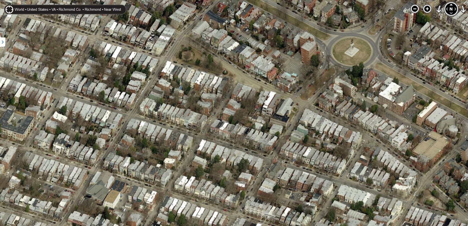
The Fan
.jpg)
If all Virginians lived at the density of the Fan, the urbanized area would be approximately the size of Chesterfield County.

3. Traditional Neighborhood/Pre-War Suburbs
Examples: Ghent in Norfolk, Belmont in Charlottesville,
Manchester in Richmond, Old Towne Portsmouth, Winchester Historic District,
central Roanoke
The distinction between this category and the one before it is more of a continuum than a sharp line and has to do with density and the percentage of single-family detached homes (as opposed to row homes or apartment buildings).
You might think of these as what small towns and suburbs looked like before cars ruled the world. These neighborhoods contain high concentrations of detached single-family homes with moderately-sized backyards and small front yards. A tight street grid disperses traffic, makes walking easy, and uses space efficiently. Mixed-use buildings along main streets provide most daily needs within walking distance. Small multi-family apartment buildings are concentrated along main streets or scattered throughout in configurations that make them look like single-family homes. Ideally, the mix of housing options allows for residents with a wide range of incomes, family structures, and ages. Green space is still precious and used largely for public parks and plazas.
You might think of these as what small towns and suburbs looked like before cars ruled the world. These neighborhoods contain high concentrations of detached single-family homes with moderately-sized backyards and small front yards. A tight street grid disperses traffic, makes walking easy, and uses space efficiently. Mixed-use buildings along main streets provide most daily needs within walking distance. Small multi-family apartment buildings are concentrated along main streets or scattered throughout in configurations that make them look like single-family homes. Ideally, the mix of housing options allows for residents with a wide range of incomes, family structures, and ages. Green space is still precious and used largely for public parks and plazas.
The New Urbanist (or Traditional Neighborhood Design)
movement has focused on recreating this type of neighborhood, thanks to its
versatility and attractiveness.
Traditional neighborhoods are car-compatible without being
car-dominated. Life is still possible on
foot, though most residents probably own cars.
Virginia has numerous historic examples, as well as several new neighborhoods
that have attempted to emulate this style. We also have many older neighborhoods that could fit the bill (you could say they have "good bones"), but have been gutted due to population loss or tearing down of homes and conversion of home lots into side yards.


Charlottesville's Belmont - note the neighborhood's mini-downtown and scattered corner stores. Belmont was originally a middle-class neighborhood and has a smaller housing stock.

East Beach under construction in Norfolk - this brand new neighborhood was built in a traditional neighborhood style, with interconnected streets, mixed use buildings, small front setbacks, and a mix of housing types.

Ghent in Norfolk. Note the large single-family homes with commercial and apartment buildings along the main roads.

Winchester's Historic District
If all Virginian's lived at the density of Norfolk's Ghent, the city would fit into an area roughly the size of Richmond, Henrico County, Chesterfield County, Petersburg, and Charles City County.

4. Post-War/Inner-Ring Suburban
Examples: Annadale, Northeastern Fairfax County, Northeast
Virginia Beach, Henrico County
Built in the three or four decades after World War II, these
neighborhoods were at the forefront of America’s mass suburbanization. Designed to be accessed primarily by car, these
neighborhoods have winding and often disconnected streets that make walking
difficult and that funnel all auto traffic onto large arterials. These arterials are frequently congested (especially as development moves outward) and devoid of residents. Businesses are concentrated along arterials
in one-story, single-use strip centers, all of which provide adequate
parking. Multi-family apartment
buildings or townhomes may be scattered throughout, but set back from main
roads in configurations that allow plenty of off-street parking. Parking lots and driveways for strip centers and townhome
complexes may have almost the same footprint as the buildings they are
associated with, lending the suburb its familiar sea-of-pavement feeling. Inner-ring suburbs often support bus service, especially in poorer areas, but buses run infrequently and require public subsidy.
Most homes have backyards that are comparable to those of a
traditional neighborhood, but with larger front yards and driveways for
off-street parking. Oddly-shaped lots
and building placement leaves significant wasted (or “verdant”) green space – a
sharp contrast with traditional neighborhoods. Sidewalks are neglected, but present and occasionally used. Homes may be
fairly small and aging. In Northern Virginia, inner-ring suburbs still have sky-high property values due to the premium on homes close to DC. Outside of Nothern Virginia, many inner-ring suburbs are struggling with
declining property values and increased maintenance costs.
Many of these areas were originally built to hold a very homogenous populace - during the era of desegregation and white flight, some had homeowner's associations or private covenants that only allowed white residents. However, in recent decades, they have become some of the most diverse in the state due to the affordability of their houses and the wide range of housing options that have squeezed themselves in over the years. Many are magnets for immigrant communities. Poverty rates have also risen in places like eastern Henrico County, a trend referred to by sociologists as “the suburbanization of poverty." Increased interest in central urban areas may be helping to fuel this as poorer residents are displaced from inner-city areas.
Many of these areas were originally built to hold a very homogenous populace - during the era of desegregation and white flight, some had homeowner's associations or private covenants that only allowed white residents. However, in recent decades, they have become some of the most diverse in the state due to the affordability of their houses and the wide range of housing options that have squeezed themselves in over the years. Many are magnets for immigrant communities. Poverty rates have also risen in places like eastern Henrico County, a trend referred to by sociologists as “the suburbanization of poverty." Increased interest in central urban areas may be helping to fuel this as poorer residents are displaced from inner-city areas.

Annandale

Henrico County

Northeast Virginia Beach


Images from Kempsville in Virginia Beach
If all Virginians lived in a city the density of Annandale, the city would take up this much of the state:

5. Low-density/Outer-Ring Suburban
Examples: parts of Loudoun County, Dale City, Stafford
County, Hollymead (north Charlottesville), southern
Chesapeake, parts of York County
Again, the distinction between inner- and outer-ring suburbs is
more of a continuum than a sharp line.
Newer, outer suburbs are similar in most respects to their older
counterparts. Roads are even more
winding and disconnected than in inner-ring suburbs and cul-de-sacs are
frequent, concentrating traffic on large arterials that quickly become
congested. The difference is that this has been anticipated and the rights of way for the main arterials are often very wide to allow the road to expand to six, eight, or even ten lanes. Many outer-ring suburbs are
built near large commuter highways like I-95, I-66, US 29, or I-64. Apartments and townhomes are built in
homogenous clusters closer to the highway and strictly separated from
single-family neighborhoods. The most
dramatic difference between inner- and outer-ring suburbs may be the average
house size, which has increased steadily since the 1950’s. Some of this increase may be due to
regulations from municipalities, which are eager to ensure that the home values
(and the incomes of the residents they attract) are high enough to support the
sprawling infrastructure required. You will almost never see a new outer suburb with single-family homes less than 2000 square feet.
Public buildings like schools and parks are also much larger
and serve larger areas. The smaller
strip malls of inner-ring suburbs are replaced by enormous shopping complexes
with big box stores like Target and Costco.
Residents who are already accustomed to getting in their cars for every
trip of any kind are not put off by having to drive several miles to get to
school, work, or a shopping center.
While parking in inner-ring strip malls is adequate most of the year, parking in these new shopping centers is scaled to match the highest conceivable demand – Black Friday for a big box store. Newer suburbs may have six to eight off-street parking spaces for every vehicle in the city – equivalent to more than 3,000 square feet of pavement (not including roads) for every vehicle. Car ownership is essentially mandatory for working adults. These neighborhoods are often low on independent 20-somethings and elderly residents, who lose the ability to care for themselves as soon as they lose their drivers’ licenses. They are also subject to strict income segregation, as the lack of housing options fills each subdivision with people of approximately the same socioeconomic status. This concentration of wealth allows counties with large outer-ring suburbs to have excellent public school systems, which are in turn a draw for residents with children.
While parking in inner-ring strip malls is adequate most of the year, parking in these new shopping centers is scaled to match the highest conceivable demand – Black Friday for a big box store. Newer suburbs may have six to eight off-street parking spaces for every vehicle in the city – equivalent to more than 3,000 square feet of pavement (not including roads) for every vehicle. Car ownership is essentially mandatory for working adults. These neighborhoods are often low on independent 20-somethings and elderly residents, who lose the ability to care for themselves as soon as they lose their drivers’ licenses. They are also subject to strict income segregation, as the lack of housing options fills each subdivision with people of approximately the same socioeconomic status. This concentration of wealth allows counties with large outer-ring suburbs to have excellent public school systems, which are in turn a draw for residents with children.

Dale City - note the dependence on I-95 and the heavy clustering of retail

Hollymead, Albemarle County

Stafford County - again note the dependence on I-95, the clustering of large retail outlets, and the strict separation of single family homes from multi-family units

Chesterfield County - single-family residential areas

Chesterfield - corresponding commercial and multi-family. Note the main road that the development is built around. It's been built with a wide right of way that's allowed it to become a massive ten-lane affair.

Chesterfield - note the larger home sizes
If all Virginians lived in neighborhoods like these, the urban area would cover a fifth of the state

6. Exurban
Examples: western Loudoun County, Goochland County, parts of
Fauquier County
Exurbs are developments on the fringe of metropolitan
areas and have a range of densities. They have winding roads that are often
integrated into long-existing rural roads.
Exurban developments are built to mimic aspects of rural life, with very
large lots (an acre or more), stands of trees interspersed throughout, and
subdivisions and streets named after farms or plantations. Homes may be on septic and well water, rather
than public systems. Yet while
developments may be interspersed with legacy farms, real agriculture is rare
and usually on its way out, pushed out by high land prices and increasing
conflict with residents. The primary distinction between an exurb and a true rural
area is the exurb’s dependence on the urban economy. True rural areas are built around agriculture,
natural resource extraction, or limited local industry, and tend to be poorer
than urban areas. Exurbs, on the other
hand, are some of the wealthiest parts of the state, and are populated with
professionals working in nearby metropolitan areas.
While rural areas tend to provide a limited range of retail
options in a more scattered form, exurbs are served by the same large, high-end
shopping centers prominent in outer-ring suburbs. Exurbanites may need to drive ten to fifteen
minutes to do their shopping, but this seems normal when their commutes may be
as much as an hour one-way. Shopping
centers can draw affluent customers from a wide area to provide a full range of
goods and services.

Ivy, Albemarle County

Loudoun County near Purcellville

Wexford Hills, James City County
This screen capture from a 3-d map of Virginia and Maryland shows density as height and median household income as color - with red being poorer and green being wealthier. Exurbs are easy to spot - low density areas with high incomes at the fringe of the major metropolitan areas (including Charlottesville and Lynchburg on the lower right).
